Photo: A View over Sunnyside in 1935

By Amy O’Hair

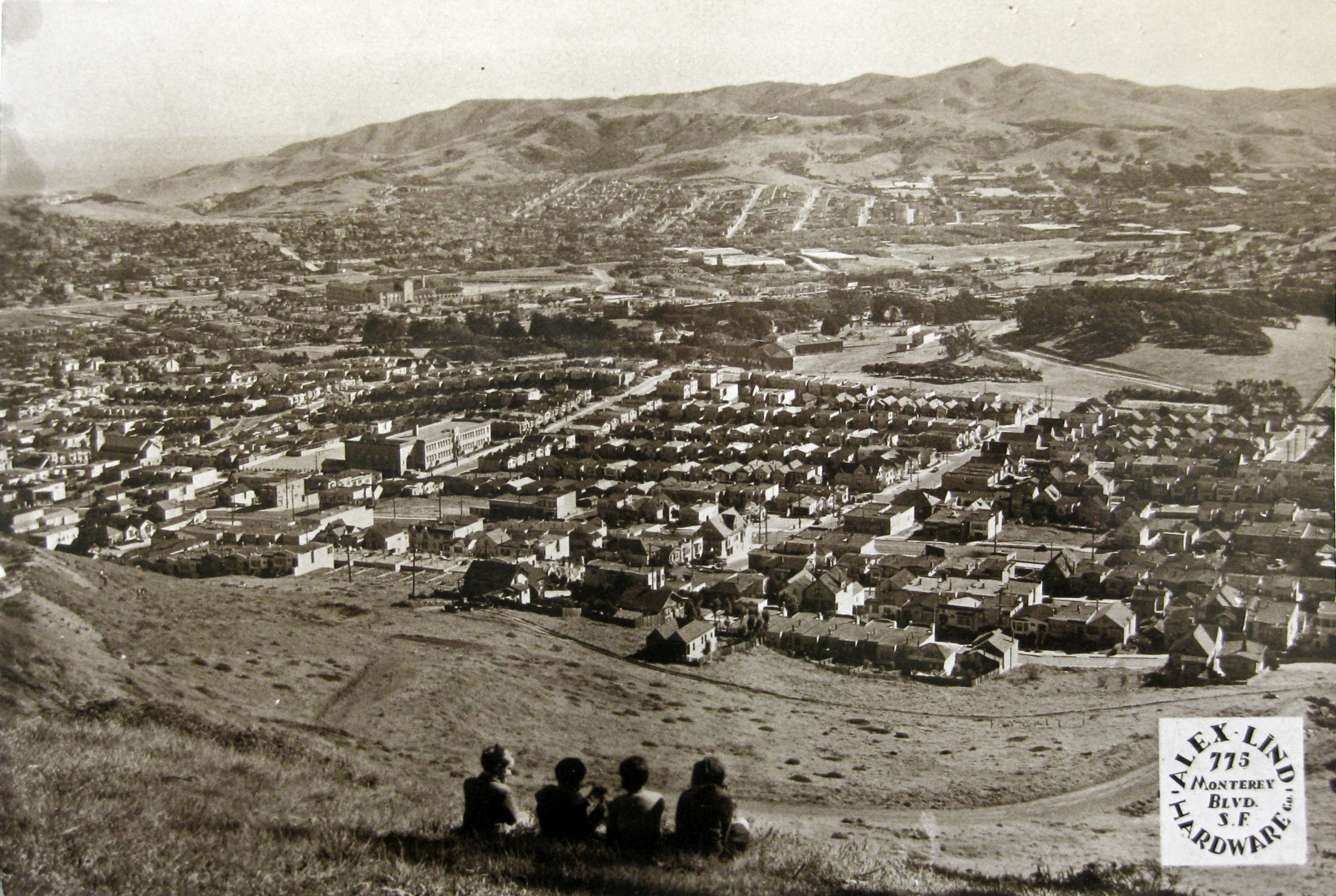
This photograph from about 1935 captures a moment in a transitional time for Sunnyside—after the building boom of the 1920s, but before the Ingleside Jail was torn down and City College built.

It was taken from what is now the 500 block of Los Palmos Drive on Mount Davidson—then just a steep grassy hillside where four children are enjoying the view. Looking southwest, the landscape shown is now in part lost. The three-winged Ingleside Jail, which occupied part of the current City College of San Francisco Ocean Campus from the 1870s until it was closed in 1934, is still visible just off Judson Avenue—an ordinary part of neighborhood life for residents then.

Sunnyside School is prominent, built only a few years before the photo. In just a couple of years, the first buildings at City College will be constructed, but at this time we see just the naked 354-foot hill. The I-280 freeway is many decades away from being built—the skinny railroad tracks where it will run through this landscape are not visible.

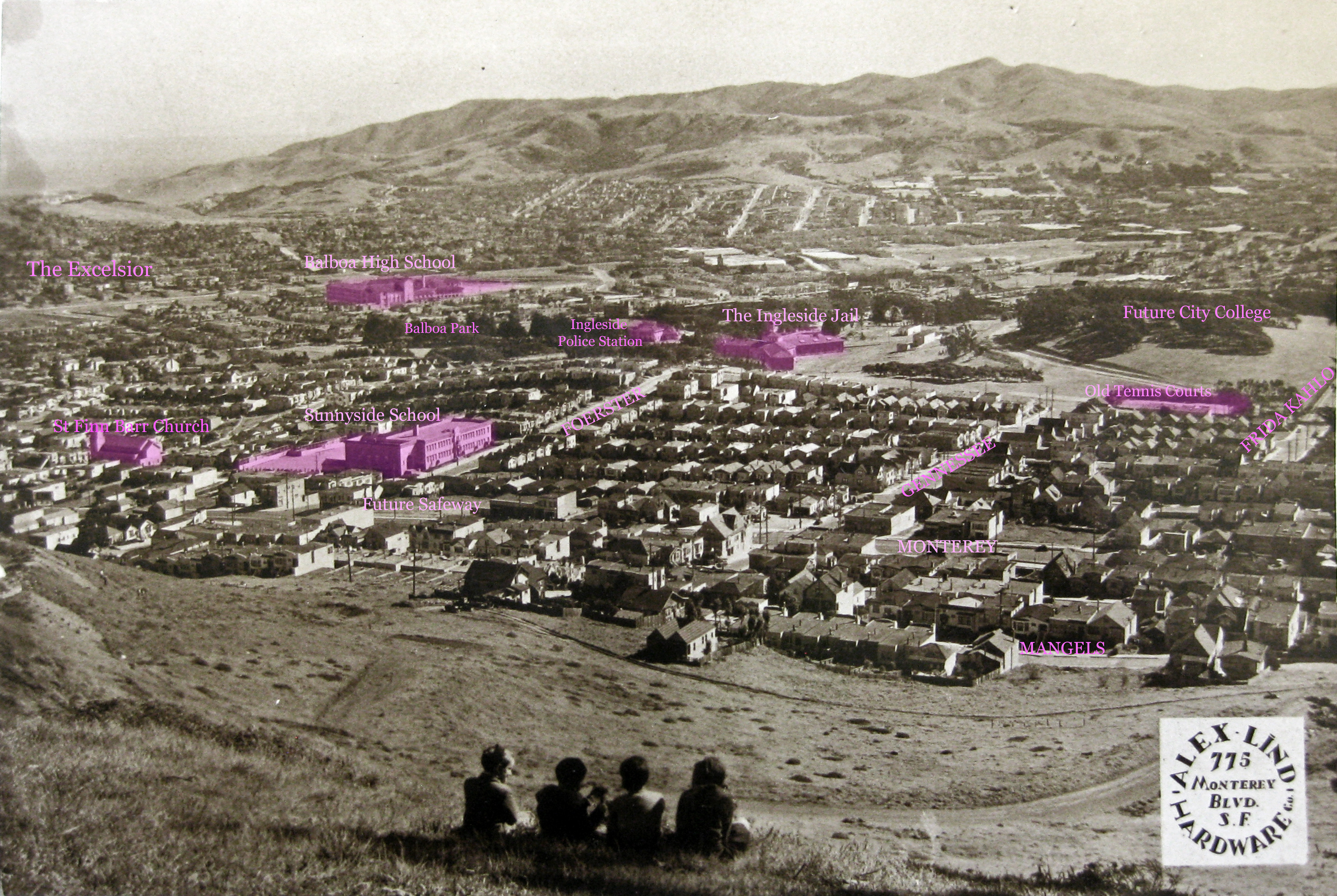
A marked version of the photo follows, to help identify sights. Click on each for a larger version.

View looking southwest over Sunnyside, San Francisco, from about 517 Los Palmos. About 1935. From a calendar published by Alex Lind Hardware, 775 Monterey Blvd. Courtesy Jacqueline Proctor.
View looking southwest over Sunnyside, San Francisco, from about 517 Los Palmos. About 1935. From a calendar published by Alex Lind Hardware, 775 Monterey Blvd. Courtesy Jacqueline Proctor. View larger version.
View looking southwest over Sunnyside, San Francisco, from about 517 Los Palmos. About 1935. Marked version to indicate landmarks such as Ingleside Jail and Sunnyside School. From a calendar published by Alex Lind Hardware, 775 Monterey Blvd. Courtesy Jacqueline Proctor.
View looking southwest over Sunnyside, San Francisco, from about 517 Los Palmos. About 1935. Marked version to indicate landmarks such as Ingleside Jail and Sunnyside School. From a calendar published by Alex Lind Hardware, 775 Monterey Blvd. Courtesy Jacqueline Proctor. View larger version.

Explore some of the sights in this image:

My thanks to Jacqueline Proctor of MtDavidson.org for this image.

Farms in Sunnyside?

1938 aerial. DavidRumsey.com

Here is a portion of the 1938 and 1948 aerial photos of San Francisco that shows the extensive farming in the area of Balboa Park below Havelock Street. This land had been used for the purpose of growing food from the 1890s until I-280 freeway was built in the 1960s. Some part of it was cultivated by inmates from the Ingleside Jail, but there was also a nursery business which leased land here.

1938-Veg-Gardens-HavelockSt
1938 aerial photo of extensive vegetable gardens below Havelock Street in Balboa Park. Land here used for that purpose from 1890s through to construction of I-280 freeway in 1960s. CLICK FOR LARGER  Photo from DavidRumsey.com, altered with labels. 
1948 aerial photo of area around present Balboa Park, still being used for vegetable gardens. Photo from DavidRumsey.com, altered with labels. 

Continue reading “Farms in Sunnyside?”

Sunnyside/Jailside: the tale of the big house down the street

OpenSFHistory.org

By Amy O’Hair

Who would site the city’s “Largest and Most Important City Subdivision” next to an extensive and notorious jail compound? That’s exactly what Behrend Joost did in 1890 when he created the Sunnyside district from a portion of the Rancho San Miguel land. Joost in any case had his eye on becoming a pioneer of the electric streetcar in San Francisco; the deleterious effect the adjacent jail might have on the neighborhood was not on his mind.

To one of the splash advertisements for Sunnyside from the day of the real estate rollout, I’ve added a little cartoon of the jail (lower left):

1891Apr26-Chron-ad-ALTEREDds
Half-page debut ad for Sunnyside, altered! SF Chronicle, 26 Apr 1891.

Located on a large 100-acre lot in the south-central area of San Francisco, the “House of Refuge” property had had a jail in some form or another since the 1850s. The city originally bought the land in 1854, when it was far, far from the little northeastern corner that was considered to constitute the city proper then.

1869 Coast Survey map, altered: House of Refuge lot marked in green. From DavidRumsey.com.

The 1905 view shown below is now unimaginable: the Jail complex has been replaced by City College of San Francisco, and the narrow railroad tracks of the San Francisco-San Jose train line that passed directly adjacent have been replaced by the Interstate 280 Freeway.

1905. View of Ingleside Jail from Ocean Avenue, looking northwest. Southern Pacific tracks run just below jail's white fence. Courtesy SFMTA. Cropped from U00341. sfmta.photoshelter.com
1905. View of Ingleside Jail complex (women’s on left, men’s on right with cupola sticking up). Looking northwest from Ocean Ave near San Jose Ave. Southern Pacific tracks run just below jail’s white fence. Courtesy SFMTA. Cropped from U00341. sfmta.photoshelter.com

Continue reading “Sunnyside/Jailside: the tale of the big house down the street”