Sunnyside, Upzoned

By Amy O’Hair

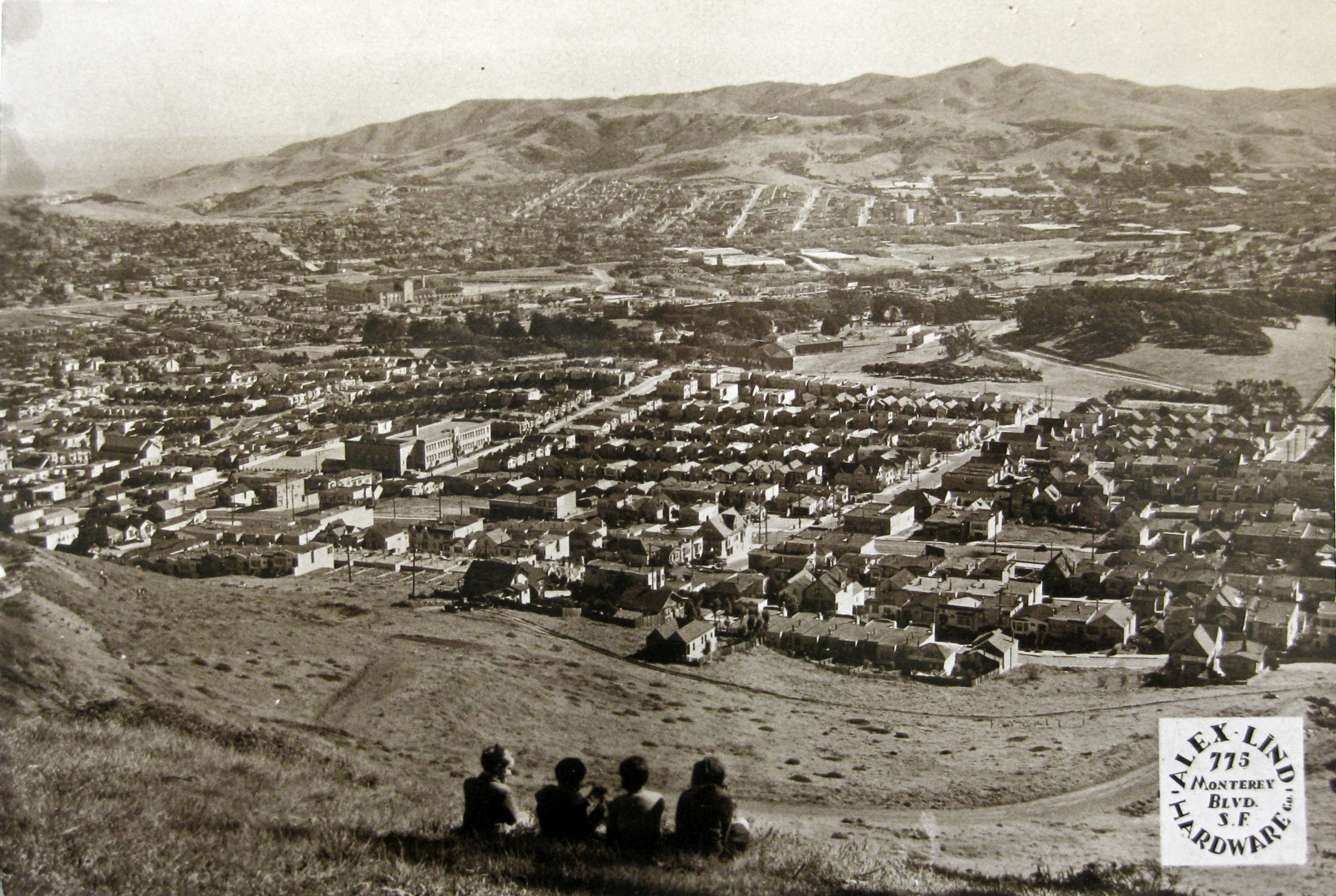
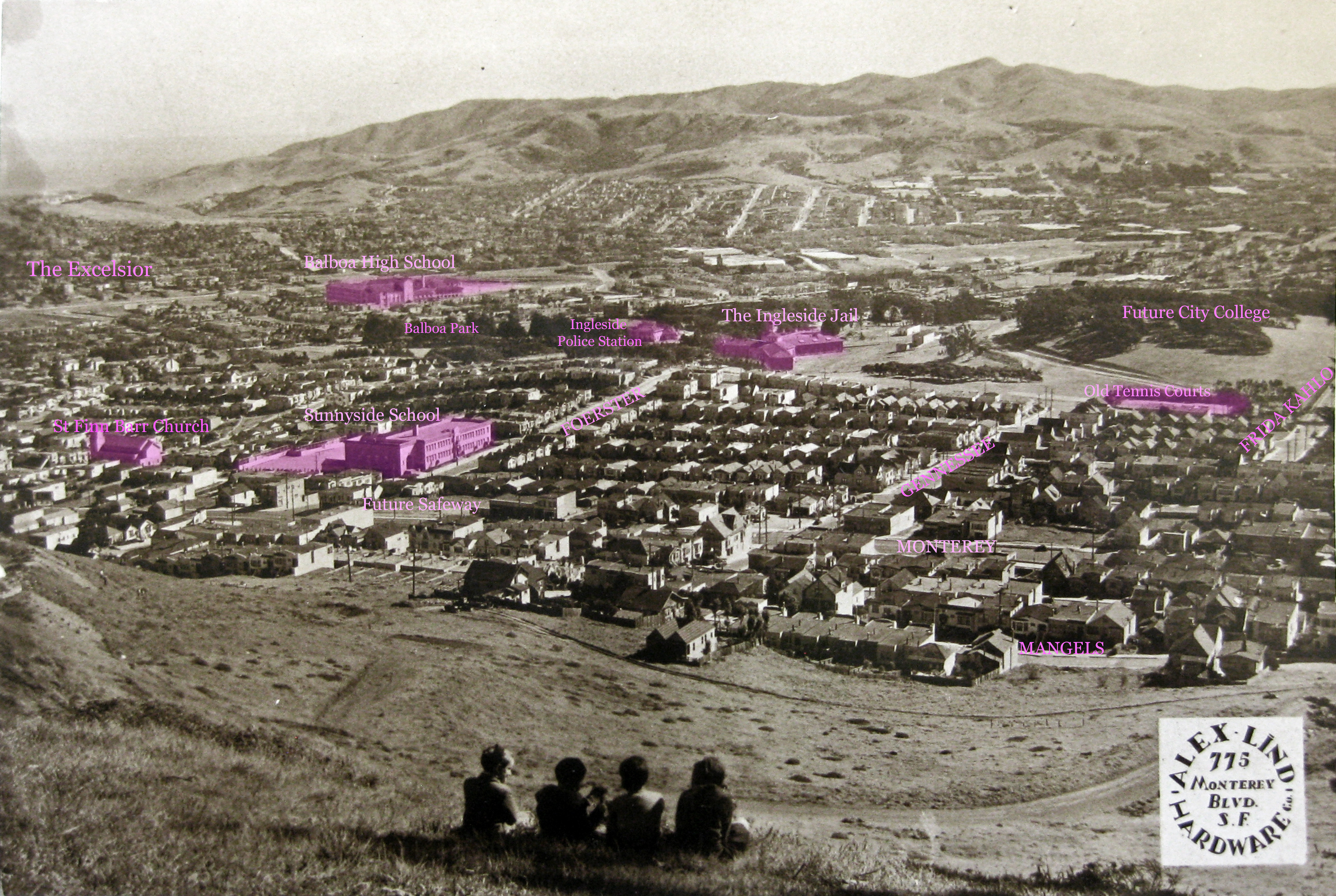
The past development of Sunnyside has been a focus of my research for posts on this site—how housing was built in the early years, how it grew, what changed over time. This week marks an important change in zoning for San Francisco, with potential future implications for this district. And we have an historical precedent here: after upzoning on Monterey Boulevard in the 1950s, a large number of new apartment buildings were constructed in the three decades that followed. Of course, zoning changes don’t make new buildings full of housing and shops appear in short order—but it does set a new direction.

Compared to more urban areas in the city, the changes for Monterey Boulevard in the new plan are pretty modest. They most dramatically affect the two blocks from Foerster to Ridgewood, and largely only on the south side of the street. The height limit of some 40 feet is increased to 65 (five-to-six stories max) over most of the changed area, with 85 feet (seven-to-eight stories max) designated for the large lot that contains the Safeway and its parking lots—a fact that ties into emerging news stories, as I’ll get to below. The height-limit changes in Sunnyside match those throughout District 7. View the whole map here.

2025 Upzoning in San Francisco, cropped to Sunnyside. Source: https://experience.arcgis.com/experience/6e0e399f9c82456dbda233eacebc433d/
2025 Upzoning in San Francisco, cropped to Sunnyside and marked. Source: https://experience.arcgis.com/experience/6e0e399f9c82456dbda233eacebc433d/

On the north side, three corner spots are included: the Kwik and Convenient and its parking lot at Foerster; Shanghai Dumpling King and the building next to it at Gennessee (east side); and four lots at Gennessee (west side) that includes Won Kok on the corner, the old bar-restaurant space at 716 Monterey, and the two houses in between. I’ve got some photo illustrations below exploring the changes.

Continue reading “Sunnyside, Upzoned”

Midcentury House Photos Now Online

By Amy O’Hair

In a few previous posts, I have mentioned the San Francisco Assessor’s Office collection of old house and building photographs, which is located in the San Francisco History Center. These photos generally date to the 1950s through the 1970s, and are not always in great condition. But for most houses, it can be the only peek a resident can get into its past appearance. They are now available online.

Before now, viewing these meant a trip to the center downtown at the Main Library for a look at the actual photograph. Now they have all been scanned, and can be downloaded as PDFs from the SF Planning Dept. Sunnyside has some blocks where many houses have photos, but unfortunately other areas are very poorly covered.  Continue reading “Midcentury House Photos Now Online”

In the Picture VII: More Sunnyside Elementary School Class Photos

View more class photos here. Read more about Sunnyside School here.

Some early class photos that have been generously shared with me by Gayle Junkin Hermann and Mary Lucid.

1937. Fourth-grade class photo, Sunnyside School, San Francisco. Photo courtesy of Gayle Junkin Hermann.
1937. fourth-grade class photo, Sunnyside School, San Francisco. Photo courtesy of Gayle Junkin Hermann. Donald Junkin (1928-2019) is on far left, top row.

The photo was mounted on a board with the studio name (Frances Thompson Studio, San Francisco) and the year. Ms Thompson appears to have encouraged the girls to bring their dolls for the photo shoot.

With border. 1937. Fourth-grade class photo, Sunnyside School, San Francisco. Photo courtesy of Gayle Junkin Hermann.
1939. Fourth-grade class photo, Sunnyside School, San Francisco. Photo courtesy of Gayle Junkin Hermann.
1939. Sixth-grade class photo, Sunnyside School, San Francisco. Photo courtesy of Gayle Junkin Hermann. Donald Junkin (1928-2019) is second from right, top row.

Continue reading “In the Picture VII: More Sunnyside Elementary School Class Photos”

Halfway to Safety: The Tale of a Little Clip and a Big Net

By Amy O’Hair

Note: This article does not include anything about the new net that was recently installed on the Golden Gate Bridge to prevent suicides.

Sometimes in my research I come across people whose lives have had a real impact on San Francisco, but whose stories have never been told; the best of those stories shine a new light on an old familiar subject. This post is about a little invention—and the person who designed it—which played a part in dramatically improving worker safety during the construction of the Golden Gate Bridge in 1936-1937. A small metal clip, invented for the purpose, enabled the fabrication of the giant nets that caught falling workers. Such nets subsequently became standard safety gear on similar work sites—a worldwide phenomenon that prevented an untold number of deaths, and a story that is anchored in San Francisco ingenuity and initiative.

Although I had found out about the man who invented the clip—he was the father of the first owner of my Sunnyside house—I am now prompted to put the story together after visiting a new local bar and restaurant, The Halfway Club, on Geneva Avenue. [January 2025: The bar was nominated for an important award.]

The place was named by its owners, Ethan Terry and Greg Quinn, in honor of the club formed by the construction workers who survived falling into the net: The Halfway to Hell Club.

More about that later. First, the net and how it got made.

Workers in the Golden Gate Bridge net. 1936. SAN FRANCISCO HISTORY CENTER, SAN FRANCISCO PUBLIC LIBRARY.
Construction workers in the Golden Gate Bridge net. 1936. SAN FRANCISCO HISTORY CENTER, SAN FRANCISCO PUBLIC LIBRARY.

A Revolutionary Net

Continue reading “Halfway to Safety: The Tale of a Little Clip and a Big Net”

‘A Guide to Friends at Night’: A Fazekas Flyer

By Amy O’Hair
All things Fazekas are found linked on this page. Information on how to restore a unit found here.

A short post to share an artifact of the Fazekas phenomenon that recently came my way—a little flyer used by salesmen for the illuminated house number units sold by his company, American Art Metal Works.

It is made of lightweight paper and is about six by three and a half inches. There is a spot on the back for the salesman’s contact information. I believe the units were sold by door-to-door salesmen, and this would be a little something to leave at the door, for either the absent or the undecided homeowner.

The unit shown on the front is the Deco style model. I estimate by the price listed on it that it dates to the mid- to late-1940s. Below is an advertisement from 1940 with the Classic unit depicted. ‘Letter drops and bell buttons to match’ says the text—the Fazekas way, suites of matching items for the home, although the house number units were always his biggest sellers.

Advertisement for Fazekas's illuminated house number units, American Art Metal Works. San Francisco Police and Peace Officer's Journal, Nov 1940. Archive.org
Advertisement for Fazekas’s illuminated house number units, American Art Metal Works. San Francisco Police and Peace Officer’s Journal, Nov 1940. Archive.org

My favorite advertisement for American Art Metal Works comes from several years before Anton Fazekas invented and patented his very successful house number units. In the 1917 San Francisco Blue Book, he placed this full-page ad. Continue reading “‘A Guide to Friends at Night’: A Fazekas Flyer”

‘And then the vision starts to form’: The Life, Work, and Death of Ida F McCain, Part Two

By Amy O’Hair
With research and collaboration by Kathleen Laderman

The second of a two-part article about San Francisco architect Ida F McCain. Read the first part here.

Having covered Ida F McCain’s early and professional life in the first part of this article, I’ll now trace her later years and death. With her older sister Eda, she became part of a unique religious movement, and they both changed their names, as so many of the followers did. For a few years, the sisters remained in California, while their niece Dorothy Darling, and other relatives, travelled to the headquarters of Father Divine’s Peace Mission movement in Philadelphia. Eventually Ida and Eda would join them there.

How did they come to the point of finally leaving their beloved California? What did the movement mean for Ida McCain? I start at a singular moment toward the end of Ida McCain’s life.

A Deed for a Higher Purpose

After a lifetime of buying and selling property, and designing beautiful buildings, it is perhaps apt that the last public act of Ida F McCain’s life should to sign her name to a deed for a beautiful building.

At the end of 1948, Ida F McCain and her sister Eda H Walters, under their Peace Mission names, appear on an extraordinary document: the deed to the grand and luxurious Lorraine Hotel in Philadelphia. This enormous structure, built in 1894 and designed by Willis G. Hale, would become not just the showplace of the Peace Mission movement, but the first hotel of this standing in the US to be fully racially integrated. The price was $485,000.[1]

The Divine Lorraine Hotel, Philadelphia. 1980s. Photographed by Joseph Elliott. Part of the Historic American Buildings Survey, Library of Congress. Wikimedia.org

Not that the sisters bought this hotel on their own; their names are third and fourth on a list that comprises five hundred co-signers, all followers of Father Divine. This was the way that the movement acquired properties, making cooperative purchases of hotels and rooming houses, which would then be occupied by followers or anyone agreeing to the code of conduct and paying their dollar a week. Communal living and working was at the center of the movement. Continue reading “‘And then the vision starts to form’: The Life, Work, and Death of Ida F McCain, Part Two”

‘And then the vision starts to form’: The Life, Work, and Death of Ida F McCain, Part One

By Amy O’Hair
With research and collaboration by Kathleen Laderman

The first of a two-part article about San Francisco architect Ida F McCain. Read the second part here.

The life of an artisan is a compelling subject for me. The worth of some famous lives may suffer under the weight of a subject’s shortcomings. But for the creative worker even faults and breaks can cast new light on the mysterious, even transcendent, process by which that person was able to bring something completely new in the world, something separate and enduring.

“It is interesting to watch the progress of your work through all the stages. First a thought—from this thought a vision comes—and then the vision starts to form—first a mere skeleton frame, but day by day it grows and, like the acorn that sends forth the mighty oak [that] no man’s hands fashion mere material to conform to the thought, the idea—until a day comes and behold—before us our vision materialized—our completed home.”[1]

Speaking to an audience of women in the 1920s, architect Ida F McCain aimed to communicate her process of creation—the exhilaration, the awe, the satisfaction of working from the originating idea to the completed structure.

But the course of a life is more like an oak tree than a house—full of twists and asymmetries, buffeted by wind or drought, hampered by disease or predation—but often magnificent nonetheless.


Ida F McCain, about 1922. Passport photo, Ancestry.com

West Coast architect Ida F McCain designed hundreds of houses in the 1910s and 1920s, in San Francisco and elsewhere—a woman prominent in her time in a profession almost entirely dominated by men. Her bungalow plans, with their thoughtful interiors, are distinctive and interesting. She boldly promoted herself, took on her own building projects as she pleased, and spoke freely about herself and her work. Her life deserves a full telling.

Continue reading “‘And then the vision starts to form’: The Life, Work, and Death of Ida F McCain, Part One”

Odds and Sods, Fazekas-Style

By Amy O’Hair
All things Fazekas are found linked on this page.

Here I present some recent sightings and readers’ contributions to the Fazekas story. The original post about Anton Fazekas’ American Art Metal Works in San Francisco was a covid-era smash hit on this otherwise low-traffic website, and continues to attract a robust viewing, as people discover they have on their house a bit of artistic flare from the mind of a midcentury sculptor.

From Canada, With Love

First, a “most prized possession” from Murray in Canada, which has an amazing story to go with it. In Murray’s own words:

“I was visiting San Francisco, maybe 30 years ago. While wandering around I noticed the illuminated number signs on all of the houses. I fell in love with them and wanted one desperately. On a drive somewhere far south of San Francisco, I spotted a flea market. I couldn’t believe my luck. I found one of the number signs, identical to the ones in San Francisco! I brought it home and wired it up for a light. What makes this story even more amazing, my home address number was 30. The number with this sign was 30, along with several of the blank enamel slide-in spacers. It illuminated my address number for years.

“Fast forward, 25 years later, I moved and I look the number sign with me. The house number of my new home was 303. I had someone paint the number 3 on one of the spacers. It’s been illuminated ever since. It’s one of my favourite possessions.”

To think, a Fazekas unit two thousand miles away on an Ontario house.

Mystery Mail

I am not a great collector of objects, but my devoted spouse gives me unusual Fazekas items from time to time, and this rare find was a holiday gift: Continue reading “Odds and Sods, Fazekas-Style”

Photo: A View over Sunnyside in 1935

By Amy O’Hair

This photograph from about 1935 captures a moment in a transitional time for Sunnyside—after the building boom of the 1920s, but before the Ingleside Jail was torn down and City College built.

It was taken from what is now the 500 block of Los Palmos Drive on Mount Davidson—then just a steep grassy hillside where four children are enjoying the view. Looking southwest, the landscape shown is now in part lost. The three-winged Ingleside Jail, which occupied part of the current City College of San Francisco Ocean Campus from the 1870s until it was closed in 1934, is still visible just off Judson Avenue—an ordinary part of neighborhood life for residents then.

Sunnyside School is prominent, built only a few years before the photo. In just a couple of years, the first buildings at City College will be constructed, but at this time we see just the naked 354-foot hill. The I-280 freeway is many decades away from being built—the skinny railroad tracks where it will run through this landscape are not visible.

A marked version of the photo follows, to help identify sights. Click on each for a larger version.

View looking southwest over Sunnyside, San Francisco, from about 517 Los Palmos. About 1935. From a calendar published by Alex Lind Hardware, 775 Monterey Blvd. Courtesy Jacqueline Proctor.
View looking southwest over Sunnyside, San Francisco, from about 517 Los Palmos. About 1935. From a calendar published by Alex Lind Hardware, 775 Monterey Blvd. Courtesy Jacqueline Proctor. View larger version.
View looking southwest over Sunnyside, San Francisco, from about 517 Los Palmos. About 1935. Marked version to indicate landmarks such as Ingleside Jail and Sunnyside School. From a calendar published by Alex Lind Hardware, 775 Monterey Blvd. Courtesy Jacqueline Proctor.
View looking southwest over Sunnyside, San Francisco, from about 517 Los Palmos. About 1935. Marked version to indicate landmarks such as Ingleside Jail and Sunnyside School. From a calendar published by Alex Lind Hardware, 775 Monterey Blvd. Courtesy Jacqueline Proctor. View larger version.

Explore some of the sights in this image:

My thanks to Jacqueline Proctor of MtDavidson.org for this image.

Catastrophe on Foerster Street: The Deadly Landslide of 1942

By Amy O’Hair
With research contributed by Kathleen Laderman

Toward the end of a long and severe El Niño, a disaster of epic proportions came to the north end of Foerster Street in Sunnyside. The Foerster Slide filled the streets with an avalanche of mud—up to twenty feet deep—flowing down from Mount Davidson. It destroyed five houses. Tragically, two people lost their lives.

The Red Cross declared it a major disaster. It was probably the single most well-documented event in Sunnyside history in the twentieth century, with many dozens of photographs taken by both newspapers and the Department of Public Works (DPW)—immediately after the event, and then days, weeks, even months later. I’ve assembled them all in this post, giving a fairly complete picture of the slide and its destruction.

The onslaught of mud swept away more than lives and houses—it marked the beginning of the end for a unique enclave of early settlers in this remote corner of Sunnyside at the foot of Mount Davidson. The source of the tons of dirt that slid down to fill the streets was due to the negligence of a contractor at work on future development. In few decades, a new residential district would cover the mountain, to be called Miraloma Park. Two of the crushed houses had been standing there since the 1890s, on large rural lots with chicken houses and vegetable gardens (and even cows for some time)—the homes of early residents who preferred to live in the unpaved and unpopulated wilds on the edge of Mount Davidson.

It was a harrowing time in any case, coming just two months after the attack on Pearl Harbor and the entrance of the United States into World War II. This local disaster’s impact was perhaps muted and short-lived, as the City prepared civil defense measures against the unknown threats to come. The general sense of alarm was high; the palpable vulnerability to further attacks on the West Coast was acute. The newspapers gave instruction on how to put out incendiary bombs, should one land on your roof (use a fine spray of water) and how to best cover windows to prevent being killed by shattering glass in a bomb blast, and told people to pack what we now call a go-bag. Get to know your Air Raid Warden! (There was one such volunteer on this very block, at 732 Foerster.) [1]

But for the families here, the Foerster Slide was an upheaval as frightening and disruptive as anything that war might bring to their block (but never did).

A Season of Floods and Landslides

Although running near the historic route of Sunnyside’s tributary of Islais Creek, the source and cause of the disastrous slide was not the creek, but an enormous pile of loose fill that had been left standing up the hill by a contractor working on grading the slope for future streets and houses. Continue reading “Catastrophe on Foerster Street: The Deadly Landslide of 1942”